top of page
WinCropData_CIESIN.jpg

MODIS Enhanced Vegetation Index (EVI)-derived winter (Oct-Mar) cropped area for 2001-2016

RUE_India_2016.jpg

Annual Rain-Use Efficiency (2000-2016)

Rain-Use Efficiency (RUE) is the ratio between annual sum of vegetation productivity and annual rainfall (i.e. NDVI per unit rainfall) for 2000-2016.

NDVI_India_2016.jpg

Annual Normalized Difference Vegetation Index (2000-2016)

MODIS-derived dataset provides the annual sum of NDVI during 2000–2016.

CHIRPS_India_2018.jpg

Add a Title

Change the text and make it your own. Click here to begin editing.

Rivers_HydroSheds.jpg

Add a Title

Change the text and make it your own. Click here to begin editing.

Map-pic.jpg

Add a Title

Change the text and make it your own. Click here to begin editing.

Accumulation_HydroSheds.jpg

Add a Title

Change the text and make it your own. Click here to begin editing.

Directions_HydroSheds.jpg

Add a Title

Change the text and make it your own. Click here to begin editing.

roads_cils.jpg

Add a Title

Change the text and make it your own. Click here to begin editing.

WinCropData_CIESIN.jpg

MODIS Enhanced Vegetation Index (EVI)-derived winter (Oct-Mar) cropped area for 2001-2016

RUE_India_2016.jpg

Annual Rain-Use Efficiency (2000-2016)

Rain-Use Efficiency (RUE) is the ratio between annual sum of vegetation productivity and annual rainfall (i.e. NDVI per unit rainfall) for 2000-2016.

NDVI_India_2016.jpg

Annual Normalized Difference Vegetation Index (2000-2016)

MODIS-derived dataset provides the annual sum of NDVI during 2000–2016.

CHIRPS_India_2018.jpg

Annual Rainfall (2000-2018)

CHIRPS-derived annual sum of rainfall during 2000-2018.

Rivers_HydroSheds.jpg

Rivers

River Network for Central India from HydroSHEDS.

Map-pic.jpg

Lakes

Lakes in Central India from HydroSHEDS.

Accumulation_HydroSheds.jpg

Flow Accumulation

Flow Accumulation for Central India from HydroSHEDS.

Directions_HydroSheds.jpg

Flow Directions

Flow Directions for Central India from HydroSHEDS.

roads_cils.jpg

Roads

The network of roads as a line vector shapefile from IndiaUnderConstruction.

canals_cils (1).jpg

Canals

The distribution of canals as line vector shapefile from IndiaUnderConstruction.

railways_cils (1).jpg

Railways

The network of railway lines as line vector shapefile from IndiaUnderConstruction.

reservoirs_cils (1).jpg

Reservoirs

The location of reservoirs as polygon vector shapefile from IndiaUnderConstruction.

mines_points_cils.jpg

Mines

The distributions of mines from IndiaUnderConstruction.

powerlines_cils.jpg

Powerlines

The distributions of high-tension power transmission lines from IndiaUnderConstruction.

DRRP-CILS-Map.jpg

This dataset contains the rural roads network from the Districts Rural Road Plan (DRRP) project.

sarika-lulc.png

Land Cover (2018)

High Resolution (3m) Land Cover Classification for 2018.

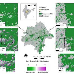
sarika-bgi.png

Bare Ground Index (2018)

Ratio of bare ground to tree cover for 2018, calculated and mapped within forest (>10% of tree cover within a 90-meter pixel).

zones_1_crop.jpg

Socio-Economic Data (Village Level)

The Central India Village-Level Geospatial Socio-Economic Data Set : 1991, 2001

labelled-wtshds-pic.png

Watersheds

Watersheds of 17 major cities within Central India

CCA-map213.4.jpg

Consensus Connectivity Areas

Regions with high levels of potential tiger movement, as agreed by 5 independent tiger connectivity studies.

bottom of page